How far is Aurangabad from Kolkata?
The distance between Kolkata (Netaji Subhas Chandra Bose International Airport) and Aurangabad (Aurangabad Airport) is 863 miles / 1389 kilometers / 750 nautical miles.
The driving distance from Kolkata (CCU) to Aurangabad (IXU) is 994 miles / 1599 kilometers, and travel time by car is about 19 hours 52 minutes.
Netaji Subhas Chandra Bose International Airport – Aurangabad Airport
Search flights

Distance from Kolkata to Aurangabad
There are several ways to calculate the distance from Kolkata to Aurangabad. Here are two standard methods:
Vincenty's formula (applied above)- 862.825 miles
- 1388.583 kilometers
- 749.775 nautical miles
Vincenty's formula calculates the distance between latitude/longitude points on the earth's surface using an ellipsoidal model of the planet.
Haversine formula- 861.732 miles
- 1386.823 kilometers
- 748.825 nautical miles
The haversine formula calculates the distance between latitude/longitude points assuming a spherical earth (great-circle distance – the shortest distance between two points).
How long does it take to fly from Kolkata to Aurangabad?
The estimated flight time from Netaji Subhas Chandra Bose International Airport to Aurangabad Airport is 2 hours and 8 minutes.
What is the time difference between Kolkata and Aurangabad?
Flight carbon footprint between Netaji Subhas Chandra Bose International Airport (CCU) and Aurangabad Airport (IXU)
On average, flying from Kolkata to Aurangabad generates about 140 kg of CO2 per passenger, and 140 kilograms equals 310 pounds (lbs). The figures are estimates and include only the CO2 generated by burning jet fuel.
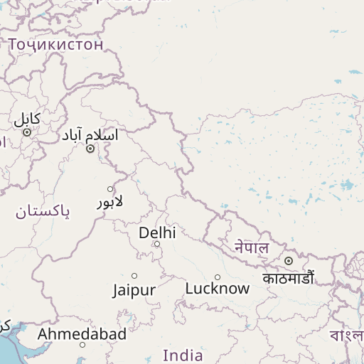
Map of flight path and driving directions from Kolkata to Aurangabad
See the map of the shortest flight path between Netaji Subhas Chandra Bose International Airport (CCU) and Aurangabad Airport (IXU).


Airport information
| Origin | Netaji Subhas Chandra Bose International Airport |
|---|---|
| City: | Kolkata |
| Country: | India |
| IATA Code: | CCU |
| ICAO Code: | VECC |
| Coordinates: | 22°39′16″N, 88°26′48″E |
| Destination | Aurangabad Airport |
|---|---|
| City: | Aurangabad |
| Country: | India |
| IATA Code: | IXU |
| ICAO Code: | VAAU |
| Coordinates: | 19°51′45″N, 75°23′53″E |