How far is Washington D.C. from Cedar Rapids, IA?
The distance between Cedar Rapids (The Eastern Iowa Airport) and Washington D.C. (Washington Dulles International Airport) is 778 miles / 1251 kilometers / 676 nautical miles.
The driving distance from Cedar Rapids (CID) to Washington D.C. (IAD) is 918 miles / 1478 kilometers, and travel time by car is about 17 hours 15 minutes.
The Eastern Iowa Airport – Washington Dulles International Airport
Search flights

Distance from Cedar Rapids to Washington D.C.
There are several ways to calculate the distance from Cedar Rapids to Washington D.C.. Here are two standard methods:
Vincenty's formula (applied above)- 777.642 miles
- 1251.494 kilometers
- 675.753 nautical miles
Vincenty's formula calculates the distance between latitude/longitude points on the earth's surface using an ellipsoidal model of the planet.
Haversine formula- 775.886 miles
- 1248.668 kilometers
- 674.227 nautical miles
The haversine formula calculates the distance between latitude/longitude points assuming a spherical earth (great-circle distance – the shortest distance between two points).
How long does it take to fly from Cedar Rapids to Washington D.C.?
The estimated flight time from The Eastern Iowa Airport to Washington Dulles International Airport is 1 hour and 58 minutes.
What is the time difference between Cedar Rapids and Washington D.C.?
Flight carbon footprint between The Eastern Iowa Airport (CID) and Washington Dulles International Airport (IAD)
On average, flying from Cedar Rapids to Washington D.C. generates about 133 kg of CO2 per passenger, and 133 kilograms equals 293 pounds (lbs). The figures are estimates and include only the CO2 generated by burning jet fuel.
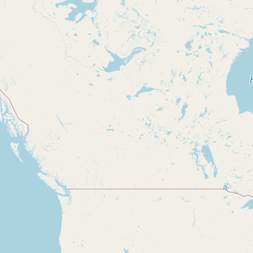
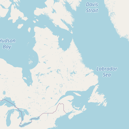
Map of flight path and driving directions from Cedar Rapids to Washington D.C.
See the map of the shortest flight path between The Eastern Iowa Airport (CID) and Washington Dulles International Airport (IAD).


Airport information
| Origin | The Eastern Iowa Airport |
|---|---|
| City: | Cedar Rapids, IA |
| Country: | United States |
| IATA Code: | CID |
| ICAO Code: | KCID |
| Coordinates: | 41°53′4″N, 91°42′38″W |
| Destination | Washington Dulles International Airport |
|---|---|
| City: | Washington D.C. |
| Country: | United States |
| IATA Code: | IAD |
| ICAO Code: | KIAD |
| Coordinates: | 38°56′40″N, 77°27′20″W |